The WBM Model Family
The Water Balance Model (WBM) was first developed at the University of New Hampshire, Durham, by Charles J. Vorosmarty in the 1990s. Since then, it has branched into a family of models designed for various applications in different spatial scale. WBM is a global-scale, gridded model that simulates both the vertical exchange of water between the ground and the atmosphere, and the horizontal transport of water through runoff and stream networks. The original WBM and its descendants predict spatially and temporally varying components of the hydrological cycle and multi constituent water quality variables. The more recent development of WBM expanded its modeling framework to many anthropogenic interactions with hydrological cycle such as coupling biogeochemical (Wollheim et al., 2008a), hydro-infrastructure engineering (Wisser et al., 2013; Wisser et al., 2008), interbasin water transfer (Zaveri et al., 2016), irrigation (Wisser et al., 2010; Grogan, 2016), agricultural land use (Grogan et al., 2017), water use regulations (Murphy et al., 2014), and many other human impacts on surface water hydrology (Vorosmarty et al., 2010). Further documentation for WBM can be found in (Grogan, 2016). Capabilities of the current version of the model include predictions of river discharge, water temperature, dissolved nitrogen, the impacts of irrigation, and the distortion of hydrographs through the operation of reservoirs. Other important features include snowmelt runoff, surface runoff due to impervious surfaces, and a series of physically-based evapotranspiration functions dependent on air temperature, vapor pressure, wind speed, and solar radiation. The WBM model family has been applied for a number of research projects at scales varying from local watersheds (Wollheim et al. 2008b, Stewart 2009) to the global system of rivers. Applications include quantifying regional impacts of irrigation on climate (Douglas et al., 2006), distribution of land use and hydrologic vulnerability (Douglas et al., 2007), magnitude of fluvial sediment trapping by reservoirs (Vorosmarty et al. 2003, Syvitzki et al., 2005), distribution of irrigation water requirements (Wisser et al. 2008) and its impact on the water cycle (Wisser et al. 2010, Fekete et al., 2010), the significance of small reservoirs as a means of rainwater harvesting and storage for irrigation(Wisser et al. 2009); global scale modeling of isotopic signatures in the hydrologic cycle (Fekete et al., 2006), and global estimate of N removal by aquatic systems (Wollheim et al. 2008b )
WBM
The current version of WBM The University of New Hampshire Water Balance Model
Preprint Geoscientific Model Development WBM: A scalable gridded global hydrologic model with water tracking functionality
WBM/WTM
The original version of WBM (Vorosmarty et al. 1998) was one of the first macroscale hydrological models and forms the basis of all its descendents.
WBMplus Model
WBMplus (Wisser et al. 2010) extends WBM by explicitly accounting for the effects of irrigation and reservoirs on the hydrological cycle. Furhtermore, it implements an improved snow melt routine, a daily time step, and a Muskingum-Cunge flood routing scheme. WBMplus is implemented in the Framework for Aquatic Modeling of the Earth System (FrAMES, Wollheim et al. 2008a). FrAMES is a grid-based, spatially distributed watershed modeling tool that allows application of biogeophysical processes over a wide range of resolutions. The modularity of FrAMES lends itself to staging and testing of new geospatial data sets as well as computer model functions depicting individual hydrologic or biogeochemical processes.
WBMplus Irrigation
WBMplus uses a tiling approach to partition each grid cell into an irrigated and non-irrigated fraction. The irrigated part can be subdivided into any number of parts representing different crops with different physiological properties and hence different water requirements (see Figure).
The estimated irrigation water demand for the entire grid cell is met by abstracting water from small reservoirs (if available), the runoff pool, representing groundwater, or river corridor discharge from rivers flowing in the same grid cell. If the demand is higher than those three sources combined, irrigation water is still applied with water taken from a virtual pool, representing abstractions from fossil groundwater that is not connected to the hydrological cycle (see Figure).
The estimated irrigation water demand for the entire grid cell can
be met my abstracting water from small reservoirs (if available), the
runoff pool, representing groundwater, or river corridor discharge from
rivers flowing the same grid cell. If the demand is higher than those
three sources combined irrigation water is still applied with water
taken from a virtual pool, representing abstactions from fossil
groundwater that is not connected to the hydrological cycle (see Figure).
WBMplus Reservoirs
The current version of the model computes water release from large reservoirs (defined at a point along the river network) as a function of inflow to the reservoir, mean annual inflow, current storage, and maximum capacity. The flexible and modular structure of the software framework allows for quick and easy implementation of other reservoir operation policies if more detailed data is available.
WBMplus Regional
The WBMplus Regional model was developed specifically for watershed-scale analyses and incorporates urban land features that are less important at larger spatial scales. This model extends the WBMplus version to combine the previous functionality of water withdrawals, and reservoir routing with hydrological processes associated with impervious surfaces, lawns, and wetland storage. In this update, a fraction of runoff from impervious surfaces is routed directly to receiving waters during each storm event and is based on previous studies of effective impervious surfaces in the basin (Pellerin et al. 2007). Lawns and impervious surfaces decrease the available water capacity in soils based on their spatial coverage and a priori estimates for lawn rooting depths. A wetland detention pool captures and slowly releases surface runoff based on a calibrated parameter. Total runoff from each grid cell is the sum of storm, surface, and groundwater release.
PWBM
PWBM (Rawlins et al., 2003) was one the first macroscale hydrological models that explictely accounted for the effects of seasonally of permanently frozen soil on components of the hydrological cycle.
More sophisticated approach to take into account permafrost influences on hydrological processes in cold region was based on coupling of simplified version of WBM with permafrost model developed at the UAF Geophysical Institute Permafrost Laboratory (GIPL) (Rawlins et al, 2013).
Water Temperature Model
A water temperature model has been coupled to the WBM/WTM to predict water temperatures under current and future climate conditions. The model mixes temperatures from surface and groundwater runoff. As water is routed, temperature is exchanged with the atmosphere using the equilibrium temperature approach from Dingman (1974). Water temperatures approach an equilibrium (defined by air temperature and solar radiation) at a rate controlled by river surface area, discharge, and exchange coefficients governed by cloud cover and wind speed. Resulting model outputs allow development of national and global scale maps of water temperature under various climate scenarios.
Nitrogen Removal Model
A nitrogen (N) module has been combined with the WBM/WTM to predict N exports from watersheds, in-channel denitrification, and resulting N concentrations throughout the river network (Wollheim et al. 2008a). The model accounts for both point and nonpoint sources of N inputs to the river network. Nonpoint sources are a function of land use type and runoff conditions. In-channel denitrification is a function of discharge, channel characteristics, and biological uptake parameters.
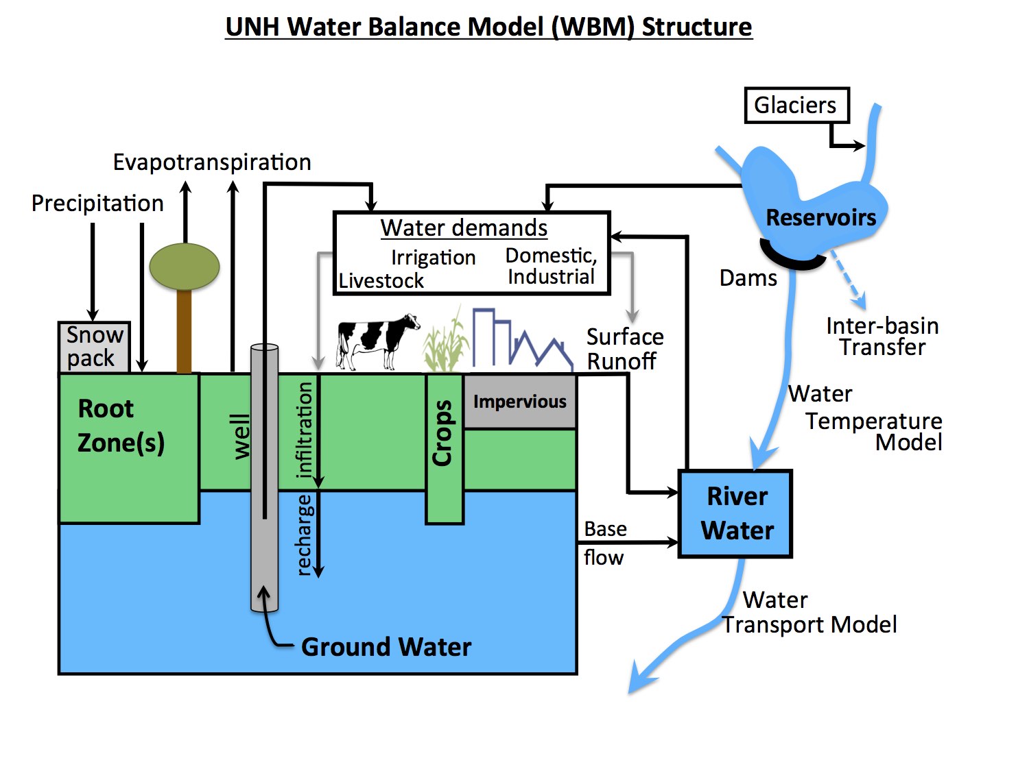
Contemporary WBM (WBM_TrANS version)
WBM was recently completely redesigned to accommodate new computational features and extended scientific functionalities under the same physical formulations of natural hydrological processes presented in earlier versions of the model. General diagram of WBM is shown on the figure.
Key publications (WBMplus):
- Wisser, D., S. Frolking, E. M. Douglas, B. M. Fekete, C. J.
Vorosmarty, and
A. H. Schumann (2008), Global irrigation water demand: Variability and
uncertainties arising from agricultural and climate data sets, Geophysical
Research Letters, 35, L24408, doi:10.1029/2008GL035296. link to article
- Wisser, D., S. Frolking, M. E. Douglas, B. M. Fekete, A. H.
Schumann
and C. J. Vorosmarty (2009), Blue and green water: The significance of
local water resources captured in small reservoirs for crop production-
a global scale analysis, Journal of Hydrology, in press, doi:
10.1016/j.jhydrol.2009.07.032. link to article
- Wisser, D., B. M. Fekete, C. J. Vorosmarty, and A. H. Schumann
(2010): Reconstructing 20th century global hydrography: a contribution
to the Global Terrestrial Network- Hydrology (GTN-H), Hydrolology
and Earth System Science, 14,1-24.
link to pdf
- Wisser D, S Frolking, S Hagen, MFP Bierkens (2013). Beyond peak reservoir storage? A global estimate of declining water storage capacity in large reservoirs, Water Resources Res., 49. link to article
- Fekete, B. M, D. Wisser, C. Kroeze, A. Bouwman, Emilio Mayorga, W. Wollheim, C. J. Vorosmarty, Millennium Ecosystem Assessment Scenario drivers (1970-2050): Climate and hydrological alterations, Global Biogeochemical Cycles
-
Stewart, Robert J. (2009), Separation of River Network Scale Nitrogen Removal Among Main Channel and Two Transient Storage Compartments, MSc. Thesis. University of New Hampshire.
- Murphy, J., J. Ozik, N. Collier, M. Altaweel, R.B. Lammers, A. Kliskey, L. Alessa, D. Cason, P. Williams (2014). Water Relationships in the US Southwest: Characterizing Water Management Networks Using Natural Language Processing, Water, 6(6), 1601-1641. link to article
- Grogan, D.S., 2016. Global and regional assessments of unsustainable groundwater use in irrigated agriculture. Doctoral Dissertations. link to article
- Grogan, D.S., D. Wisser, A. Prusevich, R.B. Lammers, S. Frolking. 2017. The use and re-use of unsustainable groundwater for irrigation: a global budget. Environmental Research Letters 12, 034017. link to article
- Zaveri, E., D.S. Grogan, K. Fisher-Vanden, S. Frolking, R.B. Lammers, D.H. Wrenn, A. Prusevich, R.E. Nichols. 2016. Invisible water, visible impact: groundwater use in Indian agriculture under climate change. Environmental Research Letters 11, 084005. link to article
- Vorosmarty, C.J., C.A. Federer and A. Schloss (1998). Potential
evaporation functions compared on U.S. watersheds: Implications for
global-scale water balance and terrestrial ecosystem modeling. Journal
of Hydrology 207: 147-69. link to article
- Vorosmarty, C.J., Green, P., Salisbury, J., and Lammers, R. 2000.
Global water resources: Vulnerability from climate change and
population growth. Science 289 (5477) pp. 284-288.DOI: 10.1126/science.289.5477.284
link to article
- Wollheim, W.M., B.J. Peterson, C.J. Vorosmarty, C.S. Hopkinson, and S.A. Thomas. 2008a. Dynamics of N removal over annual time scales in a suburban river network. Journal of Geophysical Research - Biogeosciences. G03038, doi:10.1029/2007JG000660 link to article
- Wollheim, W.M., C.J.
Vorosmarty, A.F. Bouwman, P. Green, J.A. Harrison, M. Meybeck, B.J.
Peterson, S.P. Seitzinger, and J.P. Syvitski 2008. A spatially
distributed framework for aquatic modeling of the Earth system
(FrAMES). Global Biogeochemical Cycles 22, GB2026,
doi:10.1029/2007GB002963.
link to article
- Vorosmarty,
C. J., M. Meybeck, B. Fekete, K. Sharma, P. A. Green, and J. Syvitski,
2003. Anthropogenic sediment retention: major global impact from
registered river impoundments, Global and Planetary Change 39,
169-190.
link to article
- Douglas, E. M., D. Niyogi, S. Frolking, J. B. Yeluripati, R. A. Pielke, Sr., N. Niyogi, C. J. Vorosmarty, and U. C. Mohanty (2006). Changes in moisture and energy fluxes due to agricultural land use and irrigation in the Indian Monsoon Belt. Geophysical Research Letters, 33, L14403.doi:10.1029/2006GL026550. link to article
- Vorosmarty, C. J., P. B. McIntyre, Prusevich A. A., et al. (2010). Global threats to human water security and river biodiversity., Nature 467(7315): 555-561.
- Vorosmarty, C.J., E.M. Douglas, P.A. Green, and C. Revenga
(2005).
Geospatial indicators of emerging water stress: An application to
Africa. Ambio. 34: 230-236. link to article
- Fekete, B. M., J. J. Gibson, P. Aggarwal, and C. J. Vorosmarty,
2006. Application of isotope tracers in continental scale hydrological
modeling, Journal of Hydrology 330, 444-456. link to article
- Syvitski, J. P. M., C. J. Vorosmarty, A. J. Kettner, and P.
Green,
2005. Impact of humans on the flux of terrestrial sediment to the
global coastal ocean, Science 308(5720), 376-380. link to article
-
Douglas,E. M., S. Wood, K. Sebastian and C. J. Vorosmarty. Policy
implications of a pan-tropic assessment of the simultaneous
hydrological and biodiversity impacts of deforestation. Water
Resources Management, 21 (1), 211-232, 2007. link to article
Key publications GIPL:
- Marchenko, S., V. Romanovsky, and G. Tipenko, Numerical
Modeling of Spatial Permafrost Dynamics in Alaska, In Proceedings of
the Ninth International Conference on Permafrost, June 29-July 3,
Fairbanks, Alaska, 2008, Vol. 2, pp. 1125-1130, 2008.
- Rawlins, M. A. , R.B. Lammers, S. Frolking, B. Fekete, C.J.
Vorosmarty, 2003. Simulating Pan-Arctic Runoff with a Macro-Scale
Terrestrial Water Balance Model. Hydrological Processes, 17,
pp. 2521-2539. link to article
- Rawlins, M.A., McDonald, K.C., Frolking, S., Lammers, R.B.,
Fahnestock, M., Kimball, J.S., and Vorosmarty, C.J. 2005. Remote
sensing of snow thaw at the pan-Arctic scale using the SeaWinds
scatterometer. Journal of Hydrology 312(1-4):294-311. link to article
- Rawlins, M., Frolking, S., Lammers, R.B., and Vorosmarty, C.J.
2006.
Effects of uncertainty in climate inputs on simulated
evapotranspiration and runoff in the Western Arctic. Earth
Interactions 10 doi: 10.1175/EI182.1. link to article
- Rawlins, M., D.J. Nicolsky, K. McDonald, and V.E. Romanovsky (2013). Simulating Soil Freeze/Thaw Dynamics with an Improved Pan-Arctic Water Balance Model, Journal of Advances in Modeling Earth Systems, 5, 1-17. link to article